News
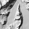
| Two New NCALM Datasets Over Alaska Now Available Two new NCALM (National Center for Airborne Laser Mapping) seed datasets are now available from OpenTopography. The dataset, "Monitoring the Mass Balance of Eklutna Glacier, AK 2023" was… |
|
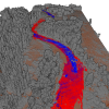
| Cullen Researcher Reveals Pre-Collapse Monitoring Of Kakhovka Dam, Ukraine By: Laurie Fickman On the morning of June 6, 2023, a substantial portion of the Kakhovka Dam in Ukraine – vital for water management and hydroelectric power generation – suffered a collapse… |
|
| Glennie Leading Effort for $63.5M DoD Contract to Revolutionize Army Decision-Making By: Laurie Fickman The University of Houston has been awarded a $63.5 million contract by the U.S. Department of Defense to help the Army make effective and timely decisions with a strong… |
|
| New NCALM Datasets in California, and Montana Now Available Three new NCALM (National Center for Airborne Laser Mapping) datasets are now available from OpenTopography. Two of these datasets examine hydrologic processes that affect channel evolution… |
|
| CEE's Hoskere Wins Grant to Research Digitizing Texas Bridges By: Stephen Greenwell An assistant professor at the Cullen College of Engineering has been awarded a three-year, $505,286 grant from the Texas Department of Transportation (TxDOT) to… |
|
| CEE's Fernandez-Diaz Tabbed as AGU LANDInG Academy Fellow By: Stephen Greenwell Juan Carlos Fernandez-Diaz, a research assistant professor in the Civil and Environmental Engineering Department and a co-investigator for the National Center for… |
|
| NCALM Seed Proposals Not Solicited in 2023 Seed Proposal Information for Students and Advisors For the past 18 years, NCALM has held an annual Seed Project competition for graduate students at U.S. institutions. These competitive,… |
|
| Cullen Researchers Part of Team Opening Window to Maya Culture By: Laurie Fickman In the ongoing quest to unearth the world's hidden mysteries, University of Houston researchers and archaeology partners have discovered a lost Maya city deep in the… |
|
| Geosensing Systems Engineering & Sciences Seeks Graduate Research Assistant Graduate Research Assistantship in Geodesy, Remote Sensing, and Geophysics The Geosensing Systems Engineering & Sciences (GSES) program in the Department of Civil and Environmental… |
|
| NCALM Announces 2022 Seed Proposal Winners 2022 Student Seed Proposal Winners Selected The National Center for Airborne Laser Mapping surveys multiple projects each year for graduate student PIs whose research would be enhanced by… |

|