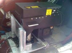
In 2004, NCALM researchers, then at the University of Florida, received funding from the Office of Naval Research to develop a single-photoelectron (photon-counting) airborne lidar system. After developing a conceptual design, contracts were given to Fibertek, Inc. to build the photomultiplier, timing, and data storage electronics, and to Sigma Space Corporation to build and purchase the optical-mechanical components (i.e., laser, optical scanner, transmit and receive optics, and housing) and assemble the instrument. The instrument was referred to as the Coastal Area Tactical-mapping System (CATS). Two University of Florida graduate students, Tristan Cossio and Kristofer Shrestha, developed software to process the observations, performed field tests, and wrote refereed papers and Ph.D. dissertations documenting the operation and performance of CATS. Limited field tests proved that the single-color, multi-channel (96 simultaneous multi-stop capable channels), sub-nanosecond laser pulse length, and single-photoelectron signal level approach to airborne lidar is viable and can produce seamless decimeter spatial resolution DEMs of terrain covered with vegetation or shallow water (e.g., streams, lakes, and coastal waters). Fibertek and Sigma Space have continued to pursue the technology used in CATS and worked on instrumentation for use in the ICESat-2 satellite that launched in 2018.
Related References
- Carter, William E., Ramesh L. Shrestha, Kenneth C. Slatton. "Photon-Counting Airborne Laser Swath Mapping (PC-ALSM)." in SPIE Proceedings, 78-85. Honolulu: SPIE, 2004. doi: 10.1117/12.581836.
- Carter, W. E., R. L. Shrestha, K. C. Slatton. "Photon Counting Airborne Laser Swath Mapping (PC-ALSM)." in Gravity, Geoid and Space Missions, edited by Christopher Jekeli, Luisa Bastos, and Joana Fernandes, 214-217. Berlin: Springer, 2005. doi: 10.1007/3-540-26932-0_37.
- Slatton, K. C., W. E. Carter, and R. Shrestha. "A Simulator for Airborne Laser Swath Mapping via Photon Counting." in SPIE Proceedings, Orlando: SPIE, 2005. doi: 10.1117/12.603759.
- Cossio, T. "Prediction of Topographic and Bathymetric Measurement Performance of Airborne Low-SNR Lidar Systems." Ph.D. dissertation, University of Florida, 2009. ufdc.ufl.edu/UFE0024246/00001.
- Cossio, T. K., K. C. Slatton, W. E. Carter, K. Y. Shrestha, and D. Harding. "Predicting Small Target Detection Performance of Low-SNR Airborne Lidar." IEEE Journal of Selected Topics in Applied Earth Observations and Remote Sensing 3, no. 4 (December 2010): 672-688. doi: 10.1109/JSTARS.2010.2053349.
- Shrestha, K. Y. "Mixed Topographic and Shallow Bathymetric Mapping via Multi-Stop Single Photoelectron Laser Ranging." Ph.D. dissertation, University of Florida, 2010. ufdc.ufl.edu/UFE0041426/00001.
- Shrestha, K. Y., W. E. Carter, K. C. Slatton, and T. K. Cossio. "Shallow Bathymetric Mapping via Multistop Single Photoelectron Sensitivity Laser Ranging." IEEE Transactions on Geoscience and Remote Sensing 50, no. 11 (November 2012): 4771-4790. doi: 10.1109/TGRS.2012.2192445.
Coastal Area Tactical-mapping System (CATS)
- Wavelength: 532 nm
- Pulse Rate: 8 kHz (100 samples/pulse, 800 kHz effective)
- Flight Altitude: 300–600 m
- Beam Divergence: 0.2 mrad
- Resolution: 20-cm point spacing at 600 m
Additional Resources
PC-ALSM/CATS (PDF)