News
| NCALM Continúa la Planificación para un Despliegue Rápido una vez que las Autoridades determinen que las Condiciones son Seguras para Trabajos de Investigación Internacionales NCALM Avanza los Preparativos para Mapeo en México y América Central El Centro Nacional de Mapeo Láser Aéreo a suspendido temporalmente los planes de las campanas de mapeo debido a las… |

|
| NCALM Continues Planning for Rapid Deployment Once Authorities Deem Conditions Safe for International Work NCALM Advances Preparations for Mapping in Mexico & Central America The National Center for Airborne Laser Mapping is holding in place due to travel restrictions from U.S. federal,… |
|
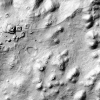
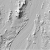
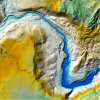
| Ridgecrest earthquake sequence NCALM lidar datasets funded by USGS & NSF released OpenTopography is pleased to announce the release of two new 2019 lidar datasets, collected by the National Center for Airborne Laser Mapping (NCALM) and funded by the U.S. Geological… |
|
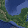
| Comenzó la Planificación para Campaña de Mapeo Lidar 2020 en México y América Central NCALM se Prepara para el Mapeo en México y América Central El Centro Nacional de Mapeo Aéreo con Laser está con mucha anticipación para iniciar la segunda campaña internacional de… |

|
| Planning Underway for 2020 Mexico and Central America Lidar Campaign NCALM Prepares for Mapping in Mexico & Central America The National Center for Airborne Laser Mapping is eager to begin the second international small-project campaign. There is… |
|
| NCALM Announces 2019 Seed Proposal Winners 2019 Student Seed Proposal Winners Selected The National Center for Airborne Laser Mapping surveys multiple projects each year for graduate student PIs whose research would be enhanced by… |

|
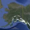
| Call for Expressions of Interest in Alaskan Airborne Lidar Campaign Alaska Airborne Lidar Collection Campaign for Small- and Medium-Sized Projects The National Center for Airborne Laser Mapping is announcing a call for expressions of interest from… |
|
| NCALM at 2019 AGU Fall Meeting National Center for Airborne Laser Mapping/Geosensing Systems Engineering & Sciences Presentations and Posters at 2019 American Geophysical Union Fall Meeting NCALM will be at the 2019… |

|
| Three new NCALM datasets released from California and Mexico OpenTopography is pleased to announce the release of three new datasets covering areas of California, and Mexico. Two of the three datasets were collected as part of NCALM's seed grant… |
|
| A Collaboration of Satellites and Villages UH Professor Continues Work With NASA and Mekong River Stakeholders To Address Flooding and Other Critical Issues Hyongki Lee, associate professor of civil and environmental engineering at… |

|