News
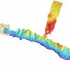
| New NCALM datasets in Central Idaho and near Ensenada, Mexico released OpenTopography is pleased to announce the release of two new NCALM lidar datasets. The first is an NCALM Seed Dataset collected for Nate Mitchell at Indiana University, Bloomington. These… |
|
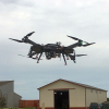
| NCALM and CRREL Enter Research and Development Agreement NCALM Expands UAS Capability The National Center for Airborne Laser Mapping entered into a Cooperative Research and Development Agreement (CRADA) with the U.S. Army Corps of Engineers' Cold… |
|
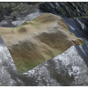
| New NCALM Datasets Capturing Post-Fire Landscapes in California, and Hurricane Harvey Impacts in Texas OpenTopography is pleased to announce the release of four new NCALM Seed datasets covering areas of California, and one hurricane rapid response project in Texas... Continue reading at… |
|
| CEE Adds 3 New Assistant Professors for Fall 2020 Semester The Civil and Environmental Engineering Department at the Cullen College of Engineering will have three new assistant professors added to its faculty for the Fall of 2020 – Dr. Vedhus… |

|
| Three New NCALM Datasets Released from California, and Utah Now Available OpenTopography is pleased to announce the release of three new NCALM SEED datasets covering areas of California, and Utah... Continue reading at OpenTopography. |
|
| NCALM Postdoc Picked for IEEE Publication Topical Editor Position A postdoctoral researcher at the University of Houston's Cullen College of Engineering has been honored with the position of topical associate editor for the Institute of Electrical and… |

|
| New NCALM Dataset Available in Southern California OpenTopography is pleased to announce the release of a new lidar dataset covering approximately 143 sq km in the San Gabriel Mountains and 183 sq km in the San Jacinto Mountains... Continue… |
|
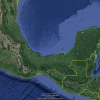
| COVID-19 Mexico and Central America Campaign Update NCALM Considers Options for Campaign The National Center for Airborne Laser Mapping is still on standby for the 2020 Mexico and Central America Lidar Collection Campaign due to travel… |
|
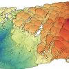
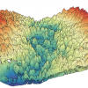
| Updated Release of Ridgecrest Earthquake Sequence NCALM Lidar Datasets Funded by USGS & NSF OpenTopography is pleased to announce the release of an updated 2019 lidar dataset, collected by the National Center for Airborne Laser Mapping and funded by the U.S. Geological Survey and… |
|
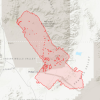
| Three New NCALM Datasets Released from California and Mexico OpenTopography is pleased to announce the release of three new datasets covering areas of California, and Mexico... Continue reading at OpenTopography. |
|