News
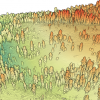
| New NCALM Dataset in North Carolina OpenTopography is pleased to announce the release of a new lidar dataset covering approximately 78 sq km near Hendersonville, North Carolina. This dataset was collected as part of an NCALM… |
|
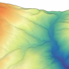
| New NCALM Lidar Data Over Yosemite National Park, California OpenTopography is pleased to announce the release of a new lidar dataset covering approximately 74 sq km covering the Illilouette Creek basin in Yosemite National Park, California. This… |
|
| Hu earns NASA funding award Xie Hu, a 2020 hire as an assistant professor in the Cullen College of Engineering's Civil and Environmental Engineering Department and at the National Center for Airborne Laser Mapping,… |

|
| NCALM Announces 2020 Seed Proposal Winners 2020 Student Seed Proposal Winners Selected The National Center for Airborne Laser Mapping surveys multiple projects each year for graduate student PIs whose research would be enhanced by… |

|
| Lee Approved for NOAA Grant to Forecast Inundation Extents For University of Houston professor Hyongki Lee, living firsthand through the calamity and destruction caused by Hurricane Harvey in 2017 has shaped his research interests, and brought to… |

|
| Long-Time Director of NCALM, Ramesh Shrestha, Hanging Up His Lidar Wings Dr. Ramesh Shrestha Retiring Dr. Ramesh Shrestha will retire in January 2021 after 35 years in academia – the last 17 as Director of the National Center for Airborne Laser Mapping. Ramesh… |

|
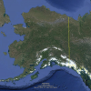
| Call for Expressions of Interest for Alaska Airborne Lidar Campaign Alaska Airborne Lidar Campaign for Small- and Medium-Sized Projects The National Center for Airborne Laser Mapping is announcing a call for expressions of interest from researchers with… |
|
| Geosensing Systems Engineering Seeks New Tenure-Track Faculty Geosensing Systems Engineering & Sciences Program Seeks Tenure-Track Faculty for Assistant Professor The Department of Civil & Environmental Engineering (CEE) at the University of… |

|
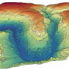
| New NCALM dataset available covering portions of Cedar Mesa and Bears Ears National Monument, Utah OpenTopography is pleased to announce the release of a new lidar dataset covering approximately 230 sq km covering Cedar Mesa and Bears Ears National Monument, Utah (Shash Jáa Unit). This… |
|
| NCALM Invites Graduate Students to Submit 2020 Seed Proposals 2020 Seed Proposal Period: October 1–December 31 The National Center for Airborne Laser Mapping invites proposals from graduate student PIs seeking airborne lidar data for use in research… |

|