News
| NCALM Announces 2021 Seed Proposal Winners 2021 Student Seed Proposal Winners Selected The National Center for Airborne Laser Mapping surveys multiple projects each year for graduate student PIs whose research would be enhanced by… |

|
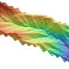
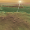
| New NCALM Lidar Dataset in Southeastern Sierra Nevada and Inyo Mountains A new lidar dataset covering approximately 133 km2 north of Ridgecrest, California, in the southeastern Sierra Nevada and Inyo Mountains, is now available on OpenTopography. This lidar… |
|
| Radar Tech From CEE's Milillo Records Antarctic Glaciers Losing Ice Faster Than Ever Documented Before By: Sally Strong In a new University of Houston study using an advanced remote imaging system known as synthetic aperture radar interferometry, three glaciers at the South Pole are… |

|
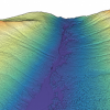
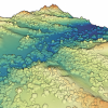
| New NCALM Dataset of Eastern Cascade Mountains, Washington Now Available A new lidar dataset covering approximately 63 sq km of the Eastern Cascade Mountains in Washington State is now available on OpenTopography. The study area is located northwest of… |
|
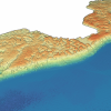
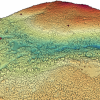
| New NCALM Dataset Along Coast of Lake Michigan, Wisconsin A new lidar dataset covering 84 sq km along the coast of Lake Michigan east of Milwaukee, Wisconsin is now available on OpenTopography. This lidar dataset was collected as part of a… |
|
| Geosensing Systems Engineering Seeks Faculty for Assistant Professor Geosensing Systems Engineering & Sciences Faculty Position The Department of Civil and Environmental Engineering (CEE) at the University of Houston invites applications for one full-… |
|
| Airborne Mapping Identifies Nearly 500 Sites and Patterns, Re-conceptualizing Early Mesoamerica Through the analysis of airborne laser mapping (lidar), an international team of researchers – including several from the Cullen College of Engineering at the University of Houston –… |
|
| New NCALM Dataset in Tahoe National Forest Available A new lidar dataset covering approximately 62 sq km within Tahoe National Forest near Truckee, California is now available on OpenTopography. This lidar dataset was collected as part of a… |
|
| NCALM Invites Graduate Students to Submit 2021 Seed Proposals 2021 Seed Proposal Period: September 27, 2021–January 7, 2022 The National Center for Airborne Laser Mapping invites proposals from graduate student PIs seeking airborne lidar data for use… |

|
| Three New NCALM Datasets from California and Oregon Available on OpenTopography Three new lidar datasets collected by the National Center for Airborne Laser Mapping in California and Oregon are now available on OpenTopography. A repeat lidar dataset of Antelope Valley… |
|