News
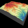
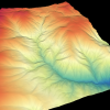
| New NCALM Dataset in Nevada Now Available A new lidar dataset covering 53 km2 over the McLeod Springs Wash in Nevada is now available on OpenTopography. This lidar dataset was collected by the National Center for Airborne… |
|
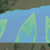
| New NCALM Dataset Over the South Padre Island, TX Available A new lidar dataset covering 61 km2 over Padre Island, TX is now available on OpenTopography. This lidar dataset was collected by the National Center for Airborne Laser Mapping (… |
|
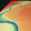
| New NCALM Dataset Over the Wax Lake Delta, LA Available A new lidar dataset covering 53 km2 in the Wax Lake Delta, LA is now available on OpenTopography. This lidar dataset was collected by the National Center for Airborne Laser Mapping (NCALM)… |
|
| NASA Grant Supports UH, UCI Project to Assess Flood Risks Using Radar Technologies By: Stephen Greenwell With a $675,000 grant from NASA, researchers at the University of Houston's Cullen College of Engineering and the University of California, Irvine are launching a… |

|
| New Ph.D. Opportunities in GSES Graduate Research Program UH's Geosensing Systems Engineering & Sciences Seeks Multiple Ph.D. Students The University of Houston's Geosensing Systems Engineering & Sciences graduate research program and… |

|
| Four New NCALM Datasets Available on OpenTopography Four new lidar datasets collected by the National Center for Airborne Laser Mapping (NCALM) are now available on OpenTopography. These include a dataset covering 73 km2 of the Marble,… |
|
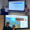
| Two Geosensing Doctoral Candidates Defend Dissertations Chi-Hung Chang and Tien Du Defend Dissertations in Fall 2021 Two students advised by Dr. Hyongki Lee, from the Geosensing Systems Engineering & Sciences (GSES) program, recently… |
|
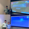
| Donghwan Kim Receives Best Dissertation Award Kim Receives Awards at Department and College Levels Geosensing Systems Engineering & Sciences Ph.D. graduate Donghwan Kim won the best dissertation award in the Department of Civil… |
|
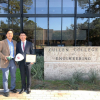
| GSES Ph.D. Candidates Defend Dissertations Andrea Albright and Sean Zhu Defend Ph.D. Dissertations in April Two doctoral candidates from the Geosensing Systems Engineering & Sciences (GSES) graduate program recently defended… |
|
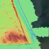
| New NCALM Dataset Northwest of Salmon, Idaho Available A new lidar dataset covering 42 km2 northwest of Salmon, Idaho is now available on OpenTopography. This lidar dataset was collected by the National Center for Airborne Laser Mapping (… |
|