News
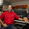
| CEE's Fernandez-Diaz Tabbed as AGU LANDInG Academy Fellow By: Stephen Greenwell Juan Carlos Fernandez-Diaz, a research assistant professor in the Civil and Environmental Engineering Department and a co-investigator for the National Center for… |
|
| NCALM Seed Proposals Not Solicited in 2023 Seed Proposal Information for Students and Advisors For the past 18 years, NCALM has held an annual Seed Project competition for graduate students at U.S. institutions. These competitive,… |

|
| Cullen Researchers Part of Team Opening Window to Maya Culture By: Laurie Fickman In the ongoing quest to unearth the world's hidden mysteries, University of Houston researchers and archaeology partners have discovered a lost Maya city deep in the… |
|
| Geosensing Systems Engineering & Sciences Seeks Graduate Research Assistant Graduate Research Assistantship in Geodesy, Remote Sensing, and Geophysics The Geosensing Systems Engineering & Sciences (GSES) program in the Department of Civil and Environmental… |
|
| NCALM Announces 2022 Seed Proposal Winners 2022 Student Seed Proposal Winners Selected The National Center for Airborne Laser Mapping surveys multiple projects each year for graduate student PIs whose research would be enhanced by… |

|
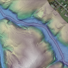
| New NCALM Datasets in California, Oregon, and North Carolina Now Available Three new NCALM (National Center for Airborne Laser Mapping) datasets are now available from OpenTopography. Two of these datasets examine snow hydrology and dynamics in the… |
|
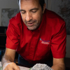
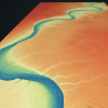
| CEE's Lee Receives Funding to Continue Flood Analysis Work Along Asia's Mekong River By: Stephen Greenwell A professor at the Cullen College of Engineering will continue serving as the lead PI for a NASA project that examines land subsidence, flood forecasting and… |

|
| New NCALM Datasets in California and Arizona Now Available Two new Seed grant datasets from NCALM (National Center for Airborne Laser Mapping) are now available from OpenTopography. On July 13th 2021 a lidar dataset within the Sierra… |
|
| NCALM Invites Graduate Students to Submit 2022 Seed Proposals 2022 Seed Proposal Period: October 10, 2022–January 13, 2023 The National Center for Airborne Laser Mapping invites proposals from graduate student PIs seeking airborne lidar data for use… |

|
| New NCALM Dataset in Nevada Now Available A new lidar dataset covering 53 km2 over the McLeod Springs Wash in Nevada is now available on OpenTopography. This lidar dataset was collected by the National Center for Airborne… |
|