News
| NCALM Unveils 2024 Seed Proposal Awardees Advancing Geoscience with Lidar Data The National Center for Airborne Laser Mapping supports innovative geoscience research through its Seed Proposal Program. Each year, NCALM surveys up to… |

|
| NCALM Seed Project Program is Back with Expanded Eligibility 2024 Seed Proposal Period: November 14, 2024–January 15, 2025 In August of 2024, NSF Division of Earth Sciences (EAR) and the Facilities and Instrumentation Program (IF) renewed funding for… |
|
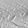
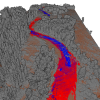
| New NCALM Datasets in CA, CO, LA, and WY Now Available Six new NCALM (National Center for Airborne Laser Mapping) datasets covering portions of California, Colorado, Louisiana, and Wyoming are now available from OpenTopography. Continue reading… |
|
| NCALM Receives NSF Renewal Funding NCALM Renewed and Will Include New Program The National Center for Airborne Laser Mapping is pleased to announce that we have received NSF funding, for two more years, in our sixth project… |

|
| C-ViSER Sees the Future of AI in Structural Engineering By: Alex Keimig Can artificial intelligence transform the practice of structural engineering? Imagine a future where structural engineers not only rely on their own knowledge and experience… |

|
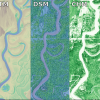
| New NCALM Datasets in Texas, Arkansas, and Idaho Now Available Three new NCALM (National Center for Airborne Laser Mapping) seed datasets covering portions of Texas, Arkansas, and Idaho are now available from OpenTopography. The dataset, "… |
|
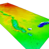
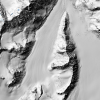
| Two New NCALM Datasets Over Alaska Now Available Two new NCALM (National Center for Airborne Laser Mapping) seed datasets are now available from OpenTopography. The dataset, "Monitoring the Mass Balance of Eklutna Glacier, AK 2023" was… |
|
| Cullen Researcher Reveals Pre-Collapse Monitoring Of Kakhovka Dam, Ukraine By: Laurie Fickman On the morning of June 6, 2023, a substantial portion of the Kakhovka Dam in Ukraine – vital for water management and hydroelectric power generation – suffered a collapse… |

|
| Glennie Leading Effort for $63.5M DoD Contract to Revolutionize Army Decision-Making By: Laurie Fickman The University of Houston has been awarded a $63.5 million contract by the U.S. Department of Defense to help the Army make effective and timely decisions with a strong… |

|
| New NCALM Datasets in California, and Montana Now Available Three new NCALM (National Center for Airborne Laser Mapping) datasets are now available from OpenTopography. Two of these datasets examine hydrologic processes that affect channel evolution… |
|