News
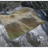
| New NCALM Dataset Available in Southern California OpenTopography is pleased to announce the release of a new lidar dataset covering approximately 143 sq km in the San Gabriel Mountains and 183 sq km in the San Jacinto Mountains... Continue… |
|
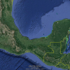
| COVID-19 Mexico and Central America Campaign Update NCALM Considers Options for Campaign The National Center for Airborne Laser Mapping is still on standby for the 2020 Mexico and Central America Lidar Collection Campaign due to travel… |

|
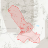
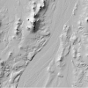
| Updated Release of Ridgecrest Earthquake Sequence NCALM Lidar Datasets Funded by USGS & NSF OpenTopography is pleased to announce the release of an updated 2019 lidar dataset, collected by the National Center for Airborne Laser Mapping and funded by the U.S. Geological Survey and… |
|
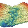
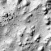
| Three New NCALM Datasets Released from California and Mexico OpenTopography is pleased to announce the release of three new datasets covering areas of California, and Mexico... Continue reading at OpenTopography. |
|
| Lee Receives Grant for South Korean Water, Satellite Project Dr. Hyongki Lee, an associate professor in the Department of Civil and Environmental Engineering at the Cullen College of Engineering, has been awarded a grant from the K-Water Institute of… |

|
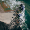
| UH Researchers Improving Resolution in 3D Data Collected by Drones Drones have become a quick and relatively inexpensive way to capture on-the-ground images of geographic areas, offering valuable information to soldiers and others. But those images have a… |
|
| NCALM Continúa la Planificación para un Despliegue Rápido una vez que las Autoridades determinen que las Condiciones son Seguras para Trabajos de Investigación Internacionales NCALM Avanza los Preparativos para Mapeo en México y América Central El Centro Nacional de Mapeo Láser Aéreo a suspendido temporalmente los planes de las campanas de mapeo debido a las… |

|
| NCALM Continues Planning for Rapid Deployment Once Authorities Deem Conditions Safe for International Work NCALM Advances Preparations for Mapping in Mexico & Central America The National Center for Airborne Laser Mapping is holding in place due to travel restrictions from U.S. federal,… |
|
| Ridgecrest earthquake sequence NCALM lidar datasets funded by USGS & NSF released OpenTopography is pleased to announce the release of two new 2019 lidar datasets, collected by the National Center for Airborne Laser Mapping (NCALM) and funded by the U.S. Geological… |
|
| Comenzó la Planificación para Campaña de Mapeo Lidar 2020 en México y América Central NCALM se Prepara para el Mapeo en México y América Central El Centro Nacional de Mapeo Aéreo con Laser está con mucha anticipación para iniciar la segunda campaña internacional de… |
|