News
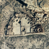
| Chaco Canyon Lidar Dataset Released Over 500 km2 of lidar data at Chaco Culture National Historical Park and the surrounding area are now available on OpenTopography. The project was mapped by NCALM in 2016 as part of an NSF… |
|
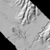
| New Lidar Dataset Covering Portion of San Andreas Fault Available OpenTopography has released a new publicly-available NCALM lidar dataset covering 28 km2 of the San Andreas Fault near Parkfield, California. The data were part of the Seed Proposal program… |
|
| NCALM Announces 2018 Seed Proposal Winners 2018 Student Seed Proposal Winners Selected The National Center for Airborne Laser Mapping surveys multiple projects each year for graduate student PIs whose research would be enhanced by… |
|
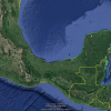
| Logistics Planning Begins for Mexico and Central America Lidar Collection Campaign Planning for the 2019 Mexico and Central America Lidar Collection Campaign for Small- and Medium-Sized Projects is ongoing. Currently there are 14 committed projects in Mexico, Belize,… |
|
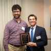
| Craig Glennie Receives Faculty Achievement Award Dr. Craig Glennie was awarded the Osman Ghazzaly Faculty Achievement Award from the Department of Civil & Environmental Engineering (CEE). The award is presented each year to an… |
|
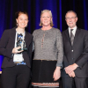
| UH GSES Student Wins at Lidar Leader Awards Geosensing Systems Engineering & Sciences student, Andrea Albright, won an Outstanding University Achievement in Lidar award for the most innovative use of lidar at this year's… |
|
| 2018 Student Seed Proposal Submission Period Extended The due date for 2018 Seed Project proposals has been extended until Friday, February 1, 2019. Due to research community requests, students will be provided additional time to apply for a… |
|
| Ekhtari Defends Ph.D. Dissertation Ph.D. candidate Nima Ekhtari defended his dissertation titled, "Land Cover and Impervious Surface Mapping Using Multispectral Airborne Laser Scanner Data." High-resolution, multispectral (… |
|
| Beloved Friend and Colleague Passes Away Faculty, staff, and students at University of Houston’s National Center for Airborne Laser Mapping are deeply saddened by the passing of our friend and colleague Laura Ann Murphy. Laura was… |

|
| NCALM Invites Seed Project Proposals from Graduate Students The National Center for Airborne Laser Mapping invites proposals from graduate students seeking airborne lidar data (up to 40 km2) for use in research toward an M.S. or Ph.D. degree. For… |
|