News
| Six New NCALM Datasets Released from California, Idaho, Washington, and Mexico OpenTopography is pleased to announce the release of six new datasets covering areas of California, Idaho, Washington, and Mexico. Four of the six datasets were collected as part of NCALM's… |
|
| NCALM Invites Seed Proposals for Graduate Student Research The National Center for Airborne Laser Mapping invites proposals from graduate students seeking airborne lidar data (up to 40 sq km) for use in research toward an M.S. or Ph.D. degree. See… |
|
| Small Projects Mapped through Community Resource Pooling Eight and a half weeks out of the country was one of NCALM's longest campaigns. The National Center for Airborne Laser Mapping field team mapped seven small archaeological projects for the… |
|
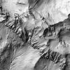
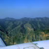
| Kern River Canyon Lidar Dataset Now Available A 250 square kilometer dataset from the Kern River Canyon is now available on OpenTopography. The area of interest was the Kern River between Bakersfield and Isabella Lake in California.… |
|
| Geosensing Systems Engineering Seeks Instructional Faculty Geosensing Systems Engineering Instructional Faculty Positions The Department of Civil & Environmental Engineering (CEE) at the University of Houston invites applications for part-time… |

|
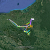
| Field Update for 2019 Mexico and Central America Lidar Collection Campaign The National Center for Airborne Laser Mapping completed four projects in Chiapas and Tabasco, Mexico, for several PIs. After small delays upon entering the country, NCALM was able to map… |
|
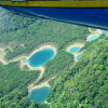
| Seed Project Data from Guadalupe Mountains Released A new NCALM dataset has been released by OpenTopography. The dataset, covering 63 km2 over McKittrick Canyon in West Texas and Southern New Mexico, was collected for a 2017 Seed Proposal… |
|
| Zhiyue Sun Defends Ph.D. Dissertation Doctoral student Zhiyue Sun successfully defended his dissertation titled, "Estimating Glacier Ice Thickness and Mass Balance using Multiple Spaceborne Geodetic Techniques." Numerous… |

|
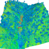
| Chaco Canyon Lidar Dataset Released Over 500 km2 of lidar data at Chaco Culture National Historical Park and the surrounding area are now available on OpenTopography. The project was mapped by NCALM in 2016 as part of an NSF… |
|
| New Lidar Dataset Covering Portion of San Andreas Fault Available OpenTopography has released a new publicly-available NCALM lidar dataset covering 28 km2 of the San Andreas Fault near Parkfield, California. The data were part of the Seed Proposal program… |
|